Saturday, July 11, 2009

Bilateral Graph

Bilateral Graphs are useful when data has both positive and negative values.
This graph represents the a lowering unemployment rate as presented by the US Treasury's press release. The line for this is not going straight down (all negative).
http://www.ustreas.gov/press/releases/

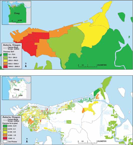
Standardized Choropleth Map

A Standardized Choropleth map is one that has been areally averaged.
This is an example showing the number of people per square kilometer in Astoria, Oregon.
http://pubs.usgs.gov/tm/tm11c2/

Thursday, July 9, 2009

Choropleth Map


A choropleth map is a type of thematic map in which areas are shaded in proportion to the measurement of the data being displayed in the map. Although they are based on statstical data, the data collected is shown over previously defined regions.
In this example, the variations are among the divorce rates between 1980 and 1990 at both the state and county level.


Wednesday, July 8, 2009

Univariate Choropleth Map

Univariate Choropleth maps show a single data set (variable).
This map shows the median income of the population of each state as provided by the United States Census Bureau.
http://mikesmaps.blogspot.com/

Bivariate Choropleth Map


Bivariate Choropleth maps show two types of data (variables) on a single map.
This bivariate map shows both the margin of victory for each presidential candidate and the voting age of those who voted.

Tuesday, July 7, 2009

Unclassed Choropleth Map


Unclassed Choropleth maps do not have defined intervals. The numeric values are converted into proportional degrees of darkness.
In this map, the darker the shading, the higher the fertility rate for countries in Europe. There is not an exact fertility rate range for each country.

Classed Choropleth Map

A Classed Choropleth map contains data that is color coded. The amount or color of shading corresponds to the key. The data is combined into smaller groups and is portrayed in intervals.
This map is classified into four groups based on the number of males per 100 females in each state.
http://my.ilstu.edu/~jrcarter/Geo204/Choro/